
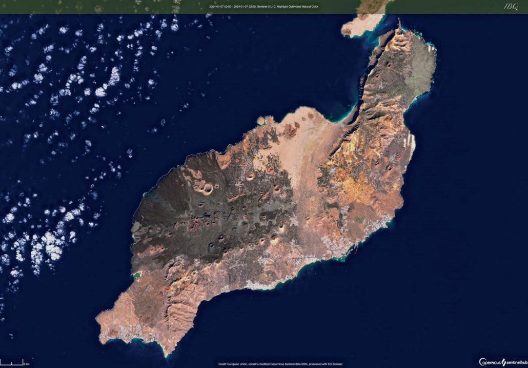
The start of the year saw several beautifully clear days, which allowed the Copernicus satellite to capture this stunning snapshot of Lanzarote in January.

This photo of Lanzarote was taken by the Copernicus satellite on 7th January 2024. Anyone who was on the island on that date will remember that it was one of several beautifully clear days that occurred over the New Year period, allowing the satellite to take a remarkably clear photo of a peaceful island on a warm winter’s day.
The photo clearly shows the extent of the volcanic eruption that occurred almost 300 years ago, and which stretches from El Golfo in the west to Tahiche in the east. It can be seen how the central ridge of much more ancient volcanoes stretching from Uga to San Bartolomé protected the southern coasts of the island.
That immense lava flow is interrupted by a corridor of sand running down the centre of the island. Called El Jable, this is where countless trillions of seashells have ended up after being crushed into sand, washed ashore at Famara in the north and gently blown down over the island by the prevailing northern winds. More sandy areas can be seen on the east coast, at Mala and Charco del Palo, as well as further north at Caletón Blanco.
We can also see how the vast majority of the population of Lanzarote live in a relatively small area stretching from Puerto Calero to Costa Teguise, and inland to Tías, San Bartolomé and Tahiche. Playa Blanca is the only really large town outside this area.
Despite rains last year, the only green areas of the island are the two golf courses at Costa Teguise and Puerto del Carmen, and the brilliant turquoise jewel of the Charco de los Clicos at El Golfo in the west. Some green tinges can also be seen in Haría in the north and the Malpaís de la Corona “badlands” in the extreme northeast have their own greyish green tinge.
In Timanfaya, we can see the reddish tones of the young volcanoes in the National Park area, as well as the paler Caldera Blanca, the largest volcanic crater on the island, which was formed 5,000 years ago.
This photo was taken on a Sunday, the day after Three Kings Day, when most islanders would be enjoying an extra day of rest and relaxation before heading back to work the following day. We don’t know for sure how many people were on the island on this day, but there’s a strong likelihood it was around 200,000.


Leave a Reply
Want to join the discussion?Feel free to contribute!